Status
The project was started in July 2014. A first version of the route was created with a total distance of about 6475km and elevation gain of 150,000m. The current version is v004.
Ressources
- The exact course of the main watershed is available thanks to Christian Eyrich.
- There are some nation-wide tracks, like the 1000 miles adventure, the Swiss National MTB routes or the Trans-Andalus.
- Official Maps for Spain by Iberipix and France from Geoportail.
Tools
Here are some Java tools that were used to create HTML and KML files:  embrtools.zip
- BaseCamp2Kml.java is the main program to convert Garmin BaseCamp gpx files into (Google Earth readable) KML files.
- PanoramioExtractor.java extracts data from Panoramio website for assigning photos to track segments and to display with Panoramio widget.
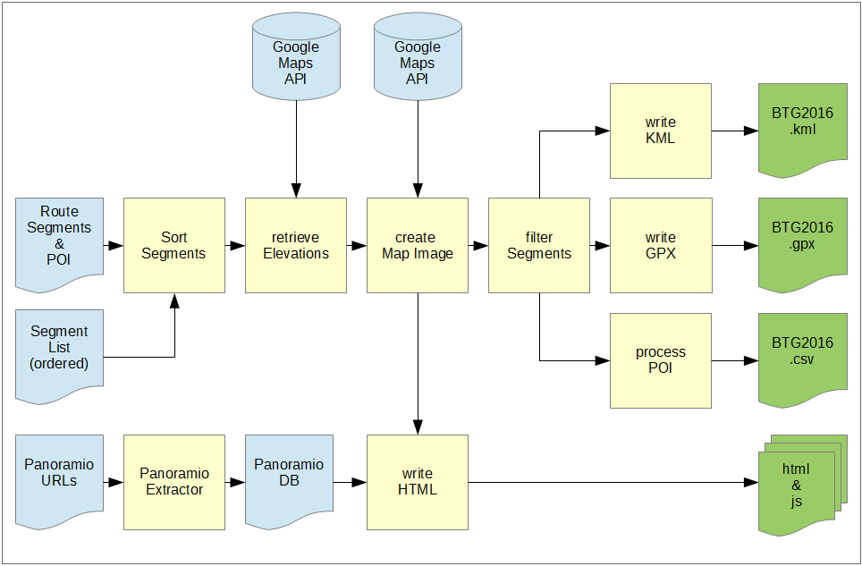
This diagram shows, how the output data of Garmin BaseCamp is processed by a custom software: In BaseCamp we have a collection of more than 100 segments. A part of those segments are combined to form the final track. They are sorted, enhanced by elevation data and finally filtered to reduce the number of track points. For compatibility with most GPS units the track is then split into parts with max. 10000 points each. It turned out that the calculated elevation gain is considerably higher than the actual measured value. Therefore the next task would be to improve the elevation filter.
Contribution
This project is too big for one person. It could be converted into a community project. Do you want to contribute? I'm looking forward to your e-mail. This is the list of ToDo's:
- Review individual sections using Google Earth and other map sources
- Test ride and rate the sections with regard to ridability, character and profile
- Find alternatives optimizing criteria as wilderness experience, elevation gain and fluency
- Create bypasses and shortcuts
- Gather of Points of Interest - especially sleeping accommodations (camping sites, cabins, bivi spots), vistas, sights and attractions
